Hurricane Gaston
Aug 27, 2004 to Sep 3, 2004Peak 75 mph985 mb
Hurricane Gaston passed within 50 miles of 43 counties in 4 states. It was strongest near Charleston County, SC, as a Category 1 on August 29, 2004.
- Major hurricane
- Hurricane
- Tropical storm
- Post-tropical
Hurricane Gaston · 2004
How it happened
Follow the storm’s path, strength and milestones.
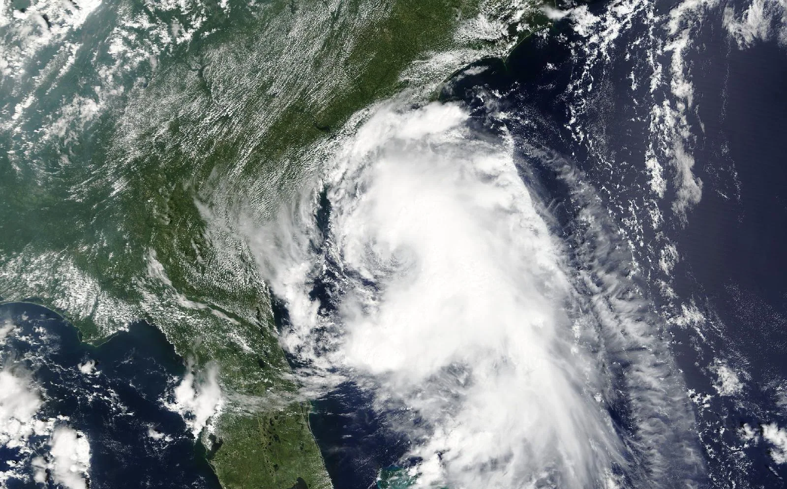
From space
Hurricane Gaston on August 28, 2004, about 22 hours before landfall in Charleston County, SC.
The storm
- Peak strength
- Category 1
- 75 mph, 65 kt
- Lowest pressure
- 985 mb
- Over the whole track
- Counties within 50 miles
- 43
- DE, MD, SC, VA
- Counties within 100 miles
- 89
- DE, GA, MA, MD, NJ, NY, RI, SC, VA
- Landfalls recorded
- 1
- Anywhere on the track
Every county it passed
Closest approach to each county boundary, with the storm’s strength at that moment.
| James City County | VA | 0.0 | Tropical storm |
| Accomack County | VA | 0.0 | Tropical storm |
| Berkeley County | SC | 0.0 | Tropical storm |
| Georgetown County | SC | 0.0 | Tropical storm |
| Florence County | SC | 0.0 | Tropical storm |
| Charleston County | SC | 0.0 | Category 1 |
| Marion County | SC | 0.0 | Tropical storm |
| Williamsburg County | SC | 0.0 | Tropical storm |
| Mathews County | VA | 0.0 | Tropical storm |
| Newport News city | VA | 1.0 | Tropical storm |
| York County | VA | 1.0 | Tropical storm |
| Northampton County | VA | 4.4 | Tropical storm |
| Williamsburg city | VA | 5.0 | Tropical storm |
| Gloucester County | VA | 5.7 | Tropical storm |
| Horry County | SC | 7.3 | Tropical storm |
| Worcester County | MD | 9.4 | Tropical storm |
| Poquoson city | VA | 11.1 | Tropical storm |
| Hampton city | VA | 11.8 | Tropical storm |
| Middlesex County | VA | 12.2 | Tropical storm |
| King and Queen County | VA | 17.1 | Tropical storm |
| Lancaster County | VA | 17.3 | Tropical storm |
| Somerset County | MD | 17.5 | Tropical storm |
| New Kent County | VA | 18.7 | Tropical storm |
| Northumberland County | VA | 21.2 | Tropical storm |
| Clarendon County | SC | 21.7 | Tropical storm |
| Norfolk city | VA | 22.3 | Tropical storm |
| Portsmouth city | VA | 22.5 | Tropical storm |
| Sumter County | SC | 24.5 | Tropical storm |
| King William County | VA | 24.5 | Tropical storm |
| Chesapeake city | VA | 25.1 | Tropical storm |
| Wicomico County | MD | 27.6 | Tropical storm |
| Sussex County | DE | 27.8 | Tropical storm |
| Dorchester County | SC | 28.3 | Category 1 |
| Virginia Beach city | VA | 29.8 | Tropical storm |
| Lee County | SC | 31.1 | Tropical storm |
| Richmond County | VA | 35.5 | Tropical storm |
| Essex County | VA | 35.8 | Tropical storm |
| Orangeburg County | SC | 35.9 | Tropical storm |
| Dorchester County | MD | 38.4 | Tropical storm |
| Hanover County | VA | 40.2 | Tropical storm |
| St. Mary's County | MD | 41.1 | Tropical storm |
| Colleton County | SC | 45.7 | Category 1 |
| Westmoreland County | VA | 46.4 | Tropical storm |
| Cape May County | NJ | 50.9 | Tropical storm |
| Calhoun County | SC | 51.8 | Tropical storm |
| Beaufort County | SC | 57.2 | Tropical storm |
| Caroline County | VA | 57.4 | Tropical storm |
| Caroline County | MD | 57.7 | Tropical storm |
| Nantucket County | MA | 59.5 | Tropical storm |
| Richland County | SC | 60.5 | Tropical storm |
| Atlantic County | NJ | 60.6 | Tropical storm |
| Calvert County | MD | 60.7 | Tropical storm |
| Talbot County | MD | 63.3 | Tropical storm |
| Kent County | DE | 64.7 | Tropical storm |
| Cumberland County | NJ | 65.3 | Tropical storm |
| Ocean County | NJ | 65.4 | Tropical storm |
| King George County | VA | 69.1 | Tropical storm |
| Charles County | MD | 69.1 | Tropical storm |
| Bamberg County | SC | 69.4 | Tropical storm |
| Burlington County | NJ | 72.2 | Tropical storm |
| Dukes County | MA | 74.1 | Tropical storm |
| Hampton County | SC | 74.1 | Category 1 |
| Jasper County | SC | 76.8 | Category 1 |
| Lexington County | SC | 78.2 | Tropical storm |
| Barnstable County | MA | 78.7 | Tropical storm |
| Prince George's County | MD | 80.5 | Tropical storm |
| Queen Anne's County | MD | 81.2 | Tropical storm |
| Stafford County | VA | 82.4 | Tropical storm |
| Chatham County | GA | 84.6 | Tropical storm |
| Washington County | RI | 85.6 | Tropical storm |
| Allendale County | SC | 85.9 | Category 1 |
| Anne Arundel County | MD | 86.1 | Tropical storm |
| Salem County | NJ | 86.3 | Tropical storm |
| Gloucester County | NJ | 86.7 | Tropical storm |
| Fredericksburg city | VA | 87.6 | Tropical storm |
| Suffolk County | NY | 88.2 | Tropical storm |
| Camden County | NJ | 88.9 | Tropical storm |
| Monmouth County | NJ | 91.7 | Tropical storm |
| Aiken County | SC | 92.0 | Tropical storm |
| Barnwell County | SC | 92.2 | Tropical storm |
| Bristol County | MA | 92.9 | Tropical storm |
| New Castle County | DE | 93.2 | Tropical storm |
| Newport County | RI | 94.1 | Tropical storm |
| Kent County | MD | 94.3 | Tropical storm |
| Prince William County | VA | 96.7 | Tropical storm |
| Culpeper County | VA | 98.0 | Tropical storm |
| Effingham County | GA | 98.1 | Tropical storm |
| Plymouth County | MA | 98.8 | Tropical storm |
| Fairfax County | VA | 99.6 | Tropical storm |
Distances are measured from hourly positions interpolated between the National Hurricane Center’s six-hourly fixes to each county boundary. Strength is shown only where the storm was still tropical. Methodology.
National Hurricane Center HURDAT2. Storm totals cover the Atlantic and Northeast and Central Pacific basins.