The severe wind outbreak of June 20, 2005
200 wind reportsMinnesota, Iowa, North Dakota and 9 more states
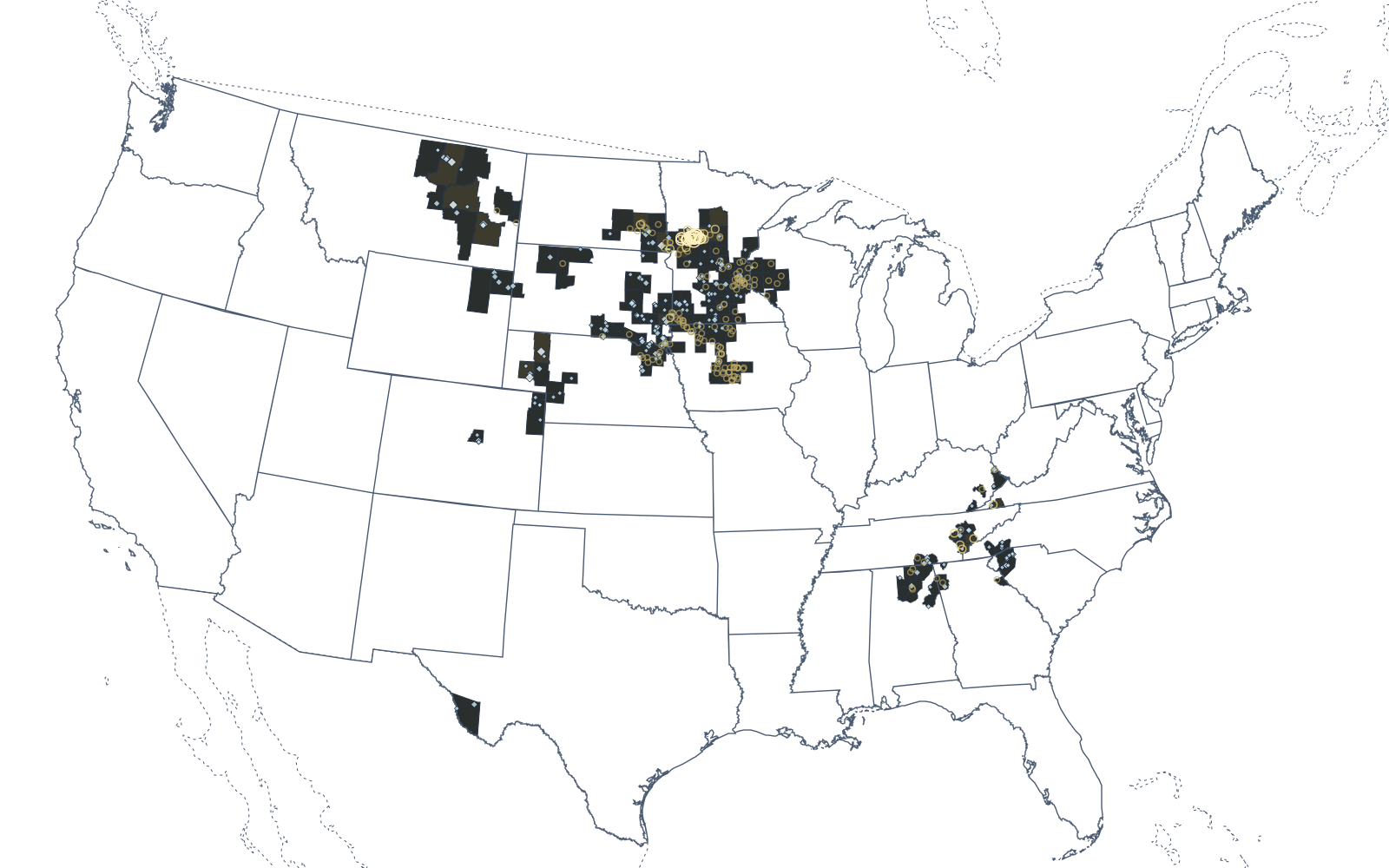
200 damaging wind reports across 12 states between 2:30 AM and 12:18 AM the next day CDT, 35 of them 65 knots (75 mph) or stronger. 198 hail reports and 8 tornadoes the same day.
Watch the day unfoldSevere wind day · June 20, 2005
How the day unfolded
Every damaging wind report of the day at its logged time, with the day's hail reports and tornadoes, and the counties they reached.
The day in numbers
- Wind reports
- 200
- on Monday, June 20, 2005
- 75 mph or more
- 35
- 15 of 86 mph (75 knots) or more
- Strongest measured gust
- —
- No measured gust reported
- Measured
- 0
- reports with an instrument reading; the rest are estimates from damage
- Killed by wind
- 0
- 3 injured
- Counties reporting
- 92
- in 12 states
Hour by hour
Damaging wind reports in each hour, Central Daylight Time.
The strongest winds
The 100 strongest reports with a speed. Measured gusts come from an instrument; estimated speeds are judged from damage.
| 11:00 AM | Otter Tail County MN | 110 mph | Estimated |
| 11:05 AM | Otter Tail County MN | 110 mph | Estimated |
| 11:05 AM | Otter Tail County MN | 110 mph | Estimated |
| 11:05 AM | Otter Tail County MN | 104 mph | Estimated |
| 11:05 AM | Otter Tail County MN | 104 mph | Estimated |
| 11:05 AM | Otter Tail County MN | 104 mph | Estimated |
| 10:25 AM | Otter Tail County MN | 90 mph | Estimated |
| 10:25 AM | Otter Tail County MN | 90 mph | Estimated |
| 10:34 AM | Otter Tail County MN | 90 mph | Estimated |
| 10:35 AM | Otter Tail County MN | 90 mph | Estimated |
| 10:35 AM | Otter Tail County MN | 90 mph | Estimated |
| 10:35 AM | Otter Tail County MN | 90 mph | Estimated |
| 10:35 AM | Otter Tail County MN | 90 mph | Estimated |
| 10:50 AM | Otter Tail County MN | 90 mph | Estimated |
| 11:18 AM | Wadena County MN | 90 mph | Estimated |
| 8:20 AM | Barnes County ND | 81 mph | Estimated |
| 10:31 AM | Otter Tail County MN | 81 mph | Estimated |
| 10:35 AM | Otter Tail County MN | 81 mph | Estimated |
| 10:50 AM | Otter Tail County MN | 81 mph | Estimated |
| 11:20 AM | Wadena County MN | 81 mph | Estimated |
| 11:30 AM | Wadena County MN | 81 mph | Estimated |
| 11:35 AM | Wadena County MN | 81 mph | Estimated |
| 11:15 AM | Wadena County MN | 76 mph | Estimated |
| 11:15 AM | Wadena County MN | 76 mph | Estimated |
| 9:35 AM | Richland County ND | 75 mph | Estimated |
| 10:22 AM | Otter Tail County MN | 75 mph | Estimated |
| 10:25 AM | Grant County MN | 75 mph | Estimated |
| 11:08 AM | Otter Tail County MN | 75 mph | Estimated |
| 11:15 AM | Cass County MN | 75 mph | Estimated |
| 12:30 PM | Monroe County TN | 75 mph | Estimated |
| 2:05 PM | Monroe County TN | 75 mph | Estimated |
| 2:15 PM | Blount County TN | 75 mph | Estimated |
| 3:20 PM | Scott County VA | 75 mph | Estimated |
| 3:40 PM | Roane County TN | 75 mph | Estimated |
| 3:40 PM | Minnehaha County SD | 75 mph | Estimated |
| 3:22 PM | Blue Earth County MN | 72 mph | Estimated |
| 11:00 AM | Todd County MN | 71 mph | Estimated |
| 2:30 AM | Tripp County SD | 70 mph | Estimated |
| 4:05 AM | Ziebach County SD | 70 mph | Estimated |
| 7:35 AM | Stutsman County ND | 70 mph | Estimated |
| 9:10 AM | Richland County ND | 70 mph | Estimated |
| 11:20 AM | Wadena County MN | 70 mph | Estimated |
| 3:22 PM | Moody County SD | 70 mph | Estimated |
| 3:35 PM | Minnehaha County SD | 70 mph | Estimated |
| 4:04 PM | Pipestone County MN | 70 mph | Estimated |
| 4:35 PM | Osceola County IA | 70 mph | Estimated |
| 4:37 PM | Dickinson County IA | 70 mph | Estimated |
| 5:40 PM | Clay County IA | 70 mph | Estimated |
| 7:30 PM | Plymouth County IA | 70 mph | Estimated |
| 8:10 PM | Marshall County IA | 70 mph | Estimated |
| 8:38 PM | Clay County SD | 70 mph | Estimated |
| 9:25 PM | Dixon County NE | 70 mph | Estimated |
| 9:35 PM | Pipestone County MN | 70 mph | Estimated |
| 11:35 PM | Charles Mix County SD | 70 mph | Estimated |
| 8:25 AM | Barnes County ND | 69 mph | Estimated |
| 8:45 AM | Barnes County ND | 69 mph | Estimated |
| 10:10 AM | Grant County MN | 69 mph | Estimated |
| 10:10 AM | Grant County MN | 69 mph | Estimated |
| 9:39 PM | Cedar County NE | 69 mph | Estimated |
| 11:20 PM | Pierce County NE | 69 mph | Estimated |
| 11:30 PM | Pierce County NE | 69 mph | Estimated |
| 12:00 AM | Knox County NE | 69 mph | Estimated |
| 12:18 AM | Pierce County NE | 69 mph | Estimated |
| 7:30 PM | Boone County IA | 67 mph | Estimated |
| 1:57 PM | Ramsey County MN | 66 mph | Estimated |
| 5:45 PM | Winnebago County IA | 66 mph | Estimated |
| 5:47 PM | Clay County IA | 66 mph | Estimated |
| 5:54 PM | Clay County IA | 66 mph | Estimated |
| 5:58 PM | Palo Alto County IA | 66 mph | Estimated |
| 6:30 PM | Webster County IA | 66 mph | Estimated |
| 6:45 PM | Webster County IA | 66 mph | Estimated |
| 7:00 PM | Greene County IA | 66 mph | Estimated |
| 7:20 PM | Greene County IA | 66 mph | Estimated |
| 7:31 PM | Story County IA | 66 mph | Estimated |
| 7:35 PM | Boone County IA | 66 mph | Estimated |
| 7:45 PM | Story County IA | 66 mph | Estimated |
| 8:12 PM | Polk County IA | 66 mph | Estimated |
| 9:54 PM | Nobles County MN | 66 mph | Estimated |
| 1:30 PM | Hennepin County MN | 64 mph | Estimated |
| 2:25 PM | Barron County WI | 64 mph | Estimated |
| 4:30 AM | Dawson County MT | 63 mph | Estimated |
| 7:55 AM | Barnes County ND | 63 mph | Estimated |
| 8:07 AM | Barnes County ND | 63 mph | Estimated |
| 8:55 AM | Cass County ND | 63 mph | Estimated |
| 9:00 AM | Ransom County ND | 63 mph | Estimated |
| 9:30 AM | Richland County ND | 63 mph | Estimated |
| 11:51 AM | Cass County MN | 63 mph | Estimated |
| 12:07 PM | Crow Wing County MN | 63 mph | Estimated |
| 12:30 PM | Crow Wing County MN | 63 mph | Estimated |
| 12:48 PM | Sherburne County MN | 63 mph | Estimated |
| 1:25 PM | Hennepin County MN | 63 mph | Estimated |
| 3:21 PM | Buffalo County WI | 63 mph | Estimated |
| 6:00 PM | Martin County KY | 63 mph | Estimated |
| 11:00 PM | Wayne County NE | 63 mph | Estimated |
| 4:30 AM | Wibaux County MT | 60 mph | Estimated |
| 9:32 AM | Richland County ND | 60 mph | Estimated |
| 9:33 AM | Richland County ND | 60 mph | Estimated |
| 11:05 AM | Stevens County MN | 60 mph | Estimated |
| 12:20 PM | Benton County MN | 60 mph | Estimated |
| 12:27 PM | Kandiyohi County MN | 60 mph | Estimated |
By state
| Minnesota | 81 | — |
| Iowa | 61 | — |
| North Dakota | 13 | — |
| South Dakota | 9 | — |
| Wisconsin | 9 | — |
| Nebraska | 8 | — |
| Tennessee | 7 | — |
| Alabama | 4 | — |
| Georgia | 3 | — |
| Montana | 2 | — |
| Kentucky | 2 | — |
| Virginia | 1 | — |
| Colorado | 0 | — |
| South Carolina | 0 | — |
| North Carolina | 0 | — |
| Wyoming | 0 | — |
| Texas | 0 | — |
Counties with the most wind reports
- Otter Tail CountyMN · 20 reports
- Story CountyIA · 9 reports
- Hennepin CountyMN · 8 reports
- Webster CountyIA · 8 reports
- Polk CountyIA · 7 reports
- Wadena CountyMN · 7 reports
- Boone CountyIA · 6 reports
- Osceola CountyIA · 5 reports
- Barnes CountyND · 5 reports
- Richland CountyND · 5 reports
Hail and tornadoes that day
198 hail reports, 6 of 2 inches or more; 8 tornadoes.
| 3:41 PM | Sheridan County NE | 4.25 |
| 8:35 PM | Morrill County NE | 4.25 |
| 10:36 PM | Phillips County MT | 2.75 |
| 4:20 AM | Garfield County MT | 2.50 |
| 3:50 AM | Custer County MT | 2.00 |
| 9:05 AM | Richland County ND | 2.00 |
| 2:45 AM | Tripp County SD | 1.75 |
| 3:30 AM | Perkins County SD | 1.75 |
| 7:40 AM | Ransom County ND | 1.75 |
| 1:48 PM | Carver County MN | 1.75 |
| 1:59 PM | Ramsey County MN | 1.75 |
| 4:05 PM | Marion County TN | 1.75 |
| 4:40 PM | Franklin County TN | 1.75 |
| 6:02 PM | Garden County NE | 1.75 |
| 7:20 PM | Clay County SD | 1.75 |
| 7:40 PM | Clay County SD | 1.75 |
| 9:10 PM | Turner County SD | 1.75 |
| 9:19 PM | Turner County SD | 1.75 |
| 9:25 PM | Phillips County MT | 1.75 |
| 9:30 PM | Cedar County NE | 1.75 |
| 9:50 PM | Phillips County MT | 1.75 |
| 10:25 PM | Phillips County MT | 1.75 |
| 10:30 PM | Sanborn County SD | 1.75 |
| 11:37 PM | Bon Homme County SD | 1.75 |
| 11:45 PM | Madison County NE | 1.75 |
| 8:15 PM | Morrill County NE | 1.25 |
| 11:25 PM | Bon Homme County SD | 1.25 |
| 1:48 PM | Renville County MN | 1.10 |
| 1:38 AM | Campbell County WY | 1.00 |
| 1:50 AM | Rosebud County MT | 1.00 |
| 1:55 AM | Crook County WY | 1.00 |
| 1:58 AM | Crook County WY | 1.00 |
| 3:01 AM | Petroleum County MT | 1.00 |
| 3:15 AM | Crook County WY | 1.00 |
| 3:40 AM | Lawrence County SD | 1.00 |
| 3:50 AM | Custer County MT | 1.00 |
| 8:10 AM | Barnes County ND | 1.00 |
| 8:10 AM | Cass County ND | 1.00 |
| 8:10 AM | Ransom County ND | 1.00 |
| 8:30 AM | Sargent County ND | 1.00 |
| 9:30 AM | Wilkin County MN | 1.00 |
| 12:05 PM | Kandiyohi County MN | 1.00 |
| 12:10 PM | Stearns County MN | 1.00 |
| 12:20 PM | Stearns County MN | 1.00 |
| 12:35 PM | Spink County SD | 1.00 |
| 12:35 PM | Sherburne County MN | 1.00 |
| 1:20 PM | Clark County SD | 1.00 |
| 1:30 PM | McLeod County MN | 1.00 |
| 1:33 PM | Anoka County MN | 1.00 |
| 2:06 PM | Presidio County TX | 1.00 |
- F1 tornado8:10 AM CDT
- F1 tornado9:44 AM CDT
- F1 tornado10:40 AM CDT
- F2 tornado10:44 AM CDT
- F2 tornado11:14 AM CDT
- F0 tornado3:25 PM CDT
- F0 tornado4:55 PM CDT
- F0 tornado9:10 PM CDT
2005 · On this date in other years · The biggest severe wind days
- A report is a single damage or measurement report to the National Weather Service. Several reports can describe one gust front, so reports are not storms.
- Reporting has grown with population, spotter networks and the internet, so counts from different decades are not directly comparable.
- Thunderstorm wind reports start at 50 knots (58 mph). SPC began flagging measured against estimated speeds in 2006; earlier reports are shown as estimated.
Storm Prediction Center severe weather database, 1955 to 2025. A day is SPC’s calendar date in Central Standard Time; a severe wind day here has 300 or more damaging wind reports, or 15 or more of 75 knots (86 mph) or more.